
The industry has shifted from stationary satellites and static images to dynamic technology and real-time observations.
Advancements to satellites over the years. The History of Satellite Images have allowed companies and government entities across the world to gather mounds of data and images of the Earth. The question then became: how can we use all this information?
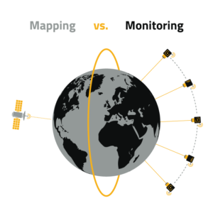
One way is to bring it all together to create a precise view of the Earth from space, otherwise known as Global Mapping. While useful for a variety of applications, these static images from stationary satellites create a patchwork that is always stuck in the past. With advanced technology and AI-powered automation, we can now consume real-time images and data and analytics that show us what the Earth looks like at any given moment. These next generation satellites monitor the Earth and deliver insights that help us predict changes before they occur. This is known as Global Monitoring.
To better understand where satellites are headed in the future, we must take a deeper dive into the differences between Global Mapping and Global Monitoring.
What Is Global Mapping?
By bringing together high-quality images and GPS controlled satellites, we can create a complete picture of the Earth through Global Mapping.
Global Mapping is the practice of using stationary satellites to deliver high-resolution images of the Earth that help create a better understanding of and predict changes in our world.
When analyzed by geographic information systems (GIS), we are better able to document and understand changes to the Earth. High-quality images of the planet through Global Mapping provide insights into weather patterns, human geography, agricultural production, environmental impacts, natural disasters and more. Global Mapping also helps analyze annual meteorological and climate data, along with various mapping applications. Other than these common use cases, Global Mapping has a variety of applications like informing agricultural production maps, assessing the environmental impacts of mining, monitoring volcanoes for public safety risks and more.
However, Global Mapping does have its limitations, including the delay in receiving images and the difficulty in navigation and course correction of the satellites delivering the data. As a result, the industry continues to uncover better ways to better use the nearly limitless amounts of data available and pursue a more dynamic earth observation approach.
What Is Global Monitoring?
Now, next-generation satellites offer on-demand tasking and high revisit rates to return real-time images, advanced observations with data and analytics through the practice of Global Monitoring.
Global Monitoring is the practice of using next-generation satellites that offer dynamic tasking and high revisit rates along with land-based sensors and IoT to deliver pattern-of-life visibility.
As opposed to the static nature of Global Mapping, Global Monitoring satellites can be easily directed to a specific location to gather data in real-time. Through AI-powered automation, the satellites analyze and detect when the physical attributes of a given area have changed and send new images to update maps instantaneously. This is then integrated with IoT data, including other sensors, data processing and communication devices, to help us understand what happened and know what to expect next.
When all these data sources are brought together in real-time, organizations can gain broader insight into global events. What’s more, these small satellites (known as small sats) can work as a group to collect enormous amounts of data and use cutting-edge AI to interpret and apply it. These types of Global Monitoring services are now a reality, enabling governments and enterprises across the world to track the changes that matter to them and deliver insights to inform action.
Satellite Monitoring Across Industries
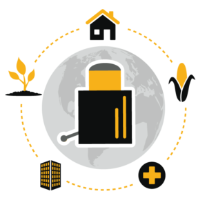
Global Monitoring is used by organizations that span many industries. Utility companies use Global Monitoring to observe pipelines, powerlines and railways. The insurance industry uses it to mitigate losses due to claims fraud. Agricultural companies apply Global Monitoring to track the health of crops and identify field boundaries. Environmental groups use the services to monitor the effects of climate change and deforestation over time. Construction and engineering companies use the advanced information to support site planning. Even recently, Global Monitoring was used to track the movement of people and goods during COVID-19 to help organizations adapt.
Global Monitoring enables critical data to be used as actionable insights in real-time that have a direct impact on industries across the world. As underlying technologies, user access platforms and the resultant intelligence continue to advance, Global Monitoring will have an even greater effect on the way we view and interact with the Earth.
