It’s clear. We are in the middle of a geospatial revolution.
From the earliest explorers until about 10 years ago, we relied on paper maps to navigate the world. They were detailed, but static…and impossible to fold. Then, Google Earth came on the scene in 2005, and suddenly we could scroll into every corner of the planet. It drastically improved how we get directions, and our houses were so cool to look at. But as we all quickly found, despite the coolness, most of the data was at least a year out of date – and in some cases much more!
Today, we’re thrilled to announce the availability of BlackSky’s global intelligence platform — the next phase of the geospatial revolution. This revolution is about looking at our world in near real time. Our news is instantaneous – so should our understanding of the world. Your phone can tell you what the planet looks like — isn’t it time to understand how it is changing on a daily or even hourly basis?
After talking to customers and partners of various sizes from across different market segments and geographies, we have created a new multi-sensor global intelligence platform — think of it as the first “Bloomberg Terminal for Space”— that allows organizations to observe and understand our world as events happen. We uniquely combine satellite data with other information feeds to provide timely insights.
In order to deliver on our BlackSky vision, we needed to accomplish three main objectives for our customers:
- Make it easy to use: The internet has revolutionized many industries. We took this same philosophy to feed you information about our world. We are providing a single portal to collect and task satellite data, and combine it with other information correlated in time and space. Before BlackSky, this was a cumbersome, human intensive process. Now the data is one click away.
- Make it timely and relevant: Markets are demanding data to observe their global assets in real time…whether they’re in oil and gas, humanitarian, financial services, agriculture, defense, manufacturing, or technology. We’re talking about persistent, always-on site or event monitoring tailored to what YOU care about.
- Reduce the cost: Today, only handful of organizations can afford to tap the power of space to solve problems and monitor infrastructure, illegal activity, or critical events. However, we think every organization in the world can benefit from this. We’re partnering with best-in-class organizations to create an entire geospatial ecosystem and passing along the savings to our customers.
The BlackSky global intelligence platform incorporates these features and allows customers to observe and understand our planet in near real time leveraging multiple data sources including satellites, unmanned aerial vehicles, ground sensors, news feed, social media, internet-of-things, and other emerging capabilities. It provides the unique ability to collect data and synthesize it by location and time frame to create understandings about our planet and the global economy. This allows our customers to solve their everyday problems by answering questions that could not be answered before.
There are two main parts of the BlackSky platform: Content (satellite images and data) and Insights.
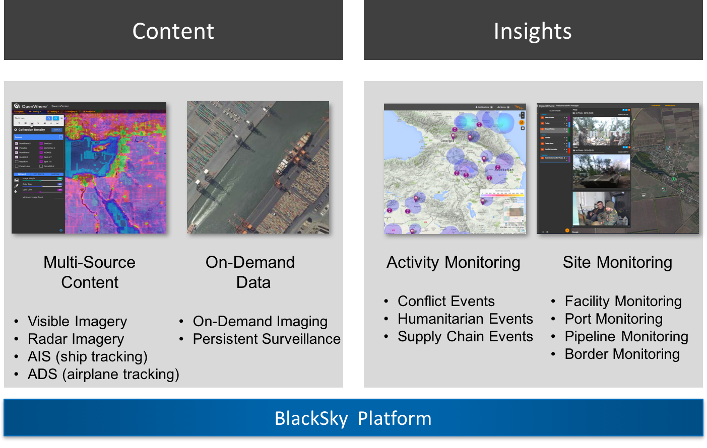
Content & Imagery
Think of it as “satellite data as a service.” No longer do you need to buy/build the satellite, launch the satellite, or operate the satellite. We’ve done the hard work for you by developing an ecosystem of the world’s leading satellite providers and delivering the content in one unifying enterprise-scale platform. Through our platform we allow our customers to observe the planet in every spectrum. This includes visible imagery, as well as other sources of data including radar, AIS (ship tracking), ADS-B (airplane tracing), news and social media and other sources.
Our customers can purchase imagery / data collected previously (archive data) as well as task spacecraft to observe or monitor specific locations, either from the BlackSky constellation of satellites of other commercial satellite sources that are part of the BlackSky ecosystem. This allows customers to get near real time updates about our changing world.
Currently, we provide images from over 10 high-resolution imaging spacecraft including 21AT’s TripleSat, SIIS’s KOMPSAT, UrtheCast’s Deimos-2 and many others — to be followed our own BlackSky constellation.
Through the easy to use web-based interface, you can quickly search the multi-source archive of millions of images, “add to shopping cart” to purchase, and download. All the images you want are delivered seamlessly online. If you can’t find the image you want, the Blacksky platform enables integrated “one-click” tasking from the user interface. The platform is the largest virtual commercial constellation offering industry leading revisit abilities.
Let’s look at a few examples. In the graphic below, I searched the BlackSky image archive for images of Seattle, where our office is located. All these frames represent available images from a few select satellite providers and filtered by date taken.
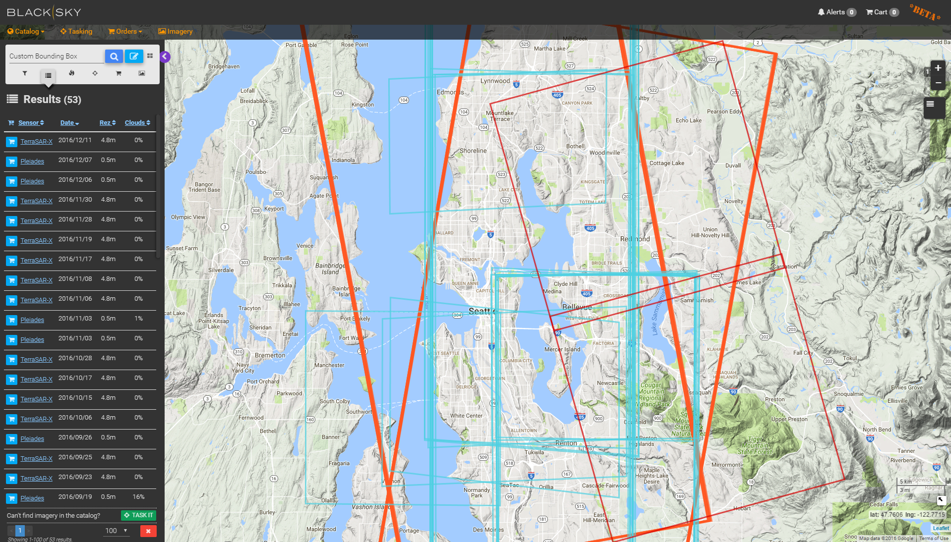
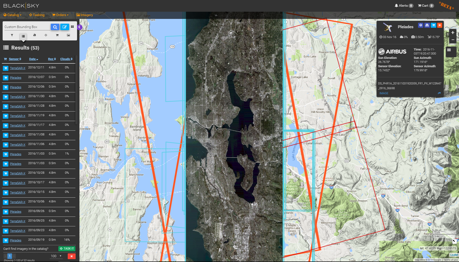
When you select one of the frames, you can see the provider, the resolution, date taken, and price. The one I selected below is from Airbus’ Pleiades satellite, and it was taken in the last few weeks. If that fits my needs, I can add it to my shopping cart and check out. Simple as that.
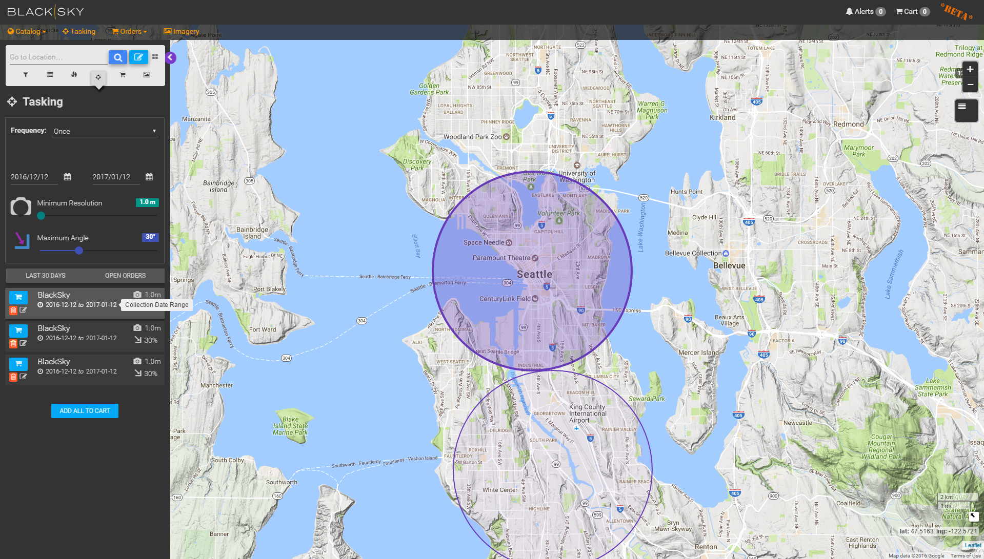
However, if the images in the archive don’t serve your needs, you can task the next available satellite making a pass over Seattle to take the most current image possible: simply click on the area you want to image (see our graphic below). Having the ability to monitor your organization’s assets is truly revolutionary…and our early adopter customers (more on them at a future date) are discovering first hand the power of this functionality.
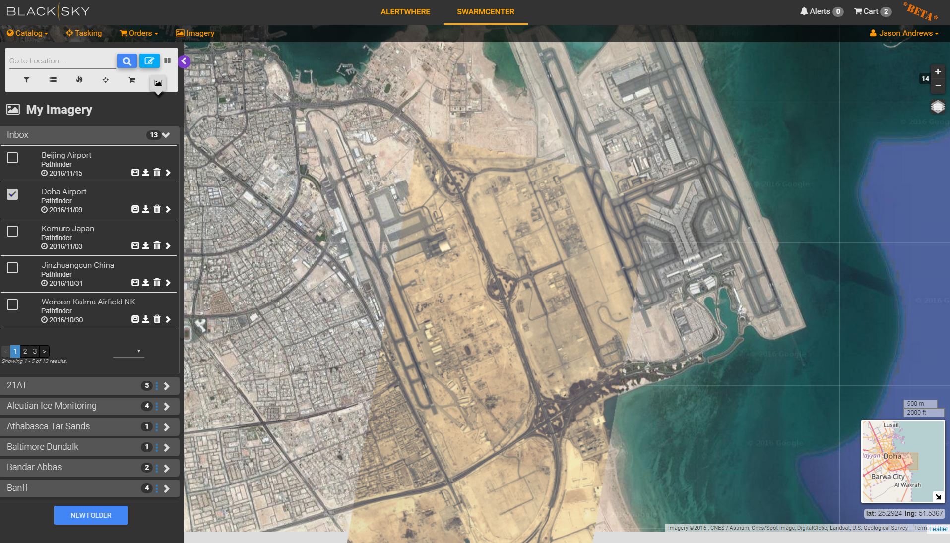
Your tasking request will be sent out to our imagery providers to ensure timely and cost effective service. In addition to our partner data providers, we are making great progress on our own BlackSky constellation. As an example, the picture below is from the BlackSky Pathfinder-1 satellite (launched in Sept. 2016) of the Doha Qatar airport. You’ll notice the high quality level of detail, ideal for monitoring economic activity.
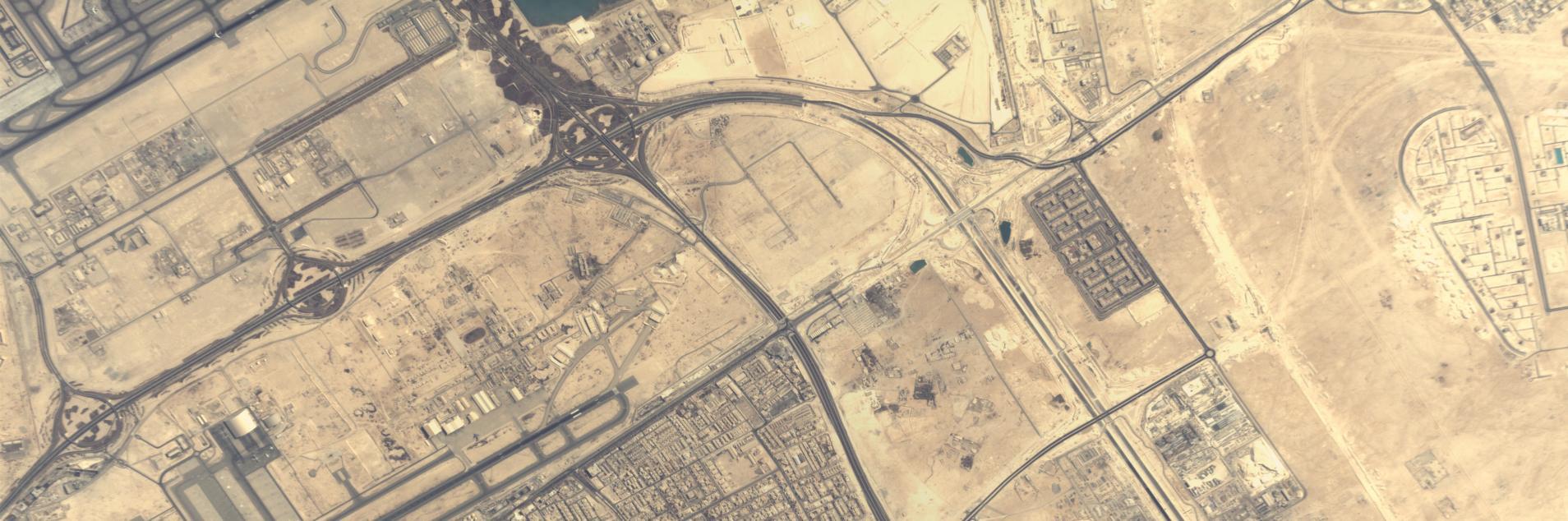
Below is the same image in the BlackSky platform overlaid on a commercial base layer, which is several years old. This is especially powerful when monitoring changes. The currency of the data, combined with the level of detail, enables you to track key economic development and activity. For example, in this specific example we captured a plane taking off!
Insights:
Having the images you want when you want them is just the beginning.The BlackSky platform goes further. Specifically, not all customers want to purchase raw imagery / data. Many want to purchase insights, or data feeds, that are relevant to their business or problem. The primary purpose of these insights is to monitor specific locations on the planet, or events, which can be grouped by theme (e.g. global conflict or natural disaster). In addition, with the platform we allow customers to fuse multiple data sources in time and space by theme or location to deepen your understanding.
How do we do this?
The BlackSky platform uses machine learning, predictive algorithms and natural language processing techniques to triangulate relevant global events in time and space. You can take advantage of this multi-source analysis by choosing the site monitoring service (watch this particular location – the port, the pipeline, the border) or event monitoring services (watch for this type of activity – conflicts, natural disasters, health/outbreaks, etc.).
The platform analyzes all this data based on your preferences and alerts you of critical events related to your area of interest – enabling you to take immediate action. For example, you could have BlackSky monitor your manufacturing facility overseas and send an alert if any natural disasters or conflicts are detected within 50 kilometers. With this information, you’re well poised to make well-informed decisions about your global assets.
Let’s play this out with some real world scenarios.
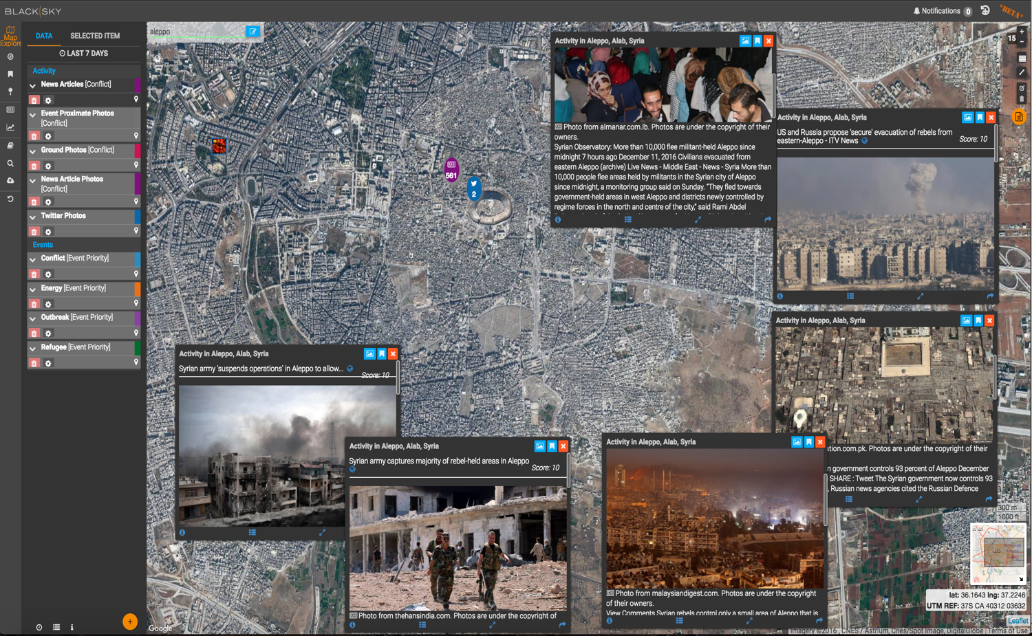
We’ve all been closely following the refugee crisis in Syria. In the example below, the BlackSky platform is used to monitor news concerning this week’s civilian evacuations in Aleppo — you can actually see the devastation from space. Note the smaller image tiles that show related information from local news outlets, geolocated to Aleppo, bringing the situation on the ground to life.
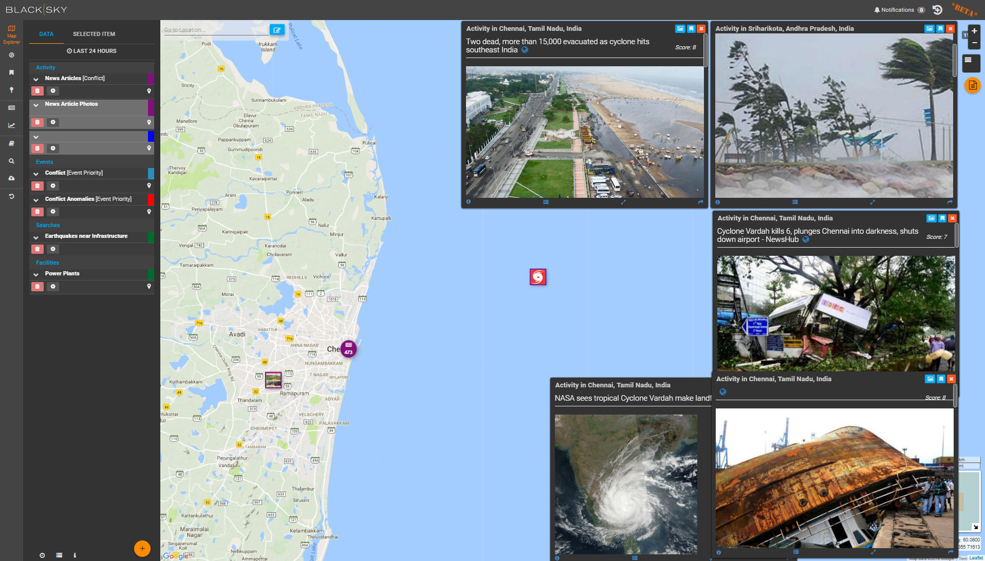
Here are some insights unearthed yesterday about a cyclone approaching Chennai, India. The platform pulls together relevant data from social media, weather sources, and news organizations to give you a real appreciation of what’s happening in the moment. You can imagine how helpful this information would be to local governments and first responders, not to mention shipping companies and other multinationals with assets in the area. Further, these same organizations can use the BlackSky platform to collect imagery once the storm passes to get an initial assessment of damage or coordinate relief efforts.
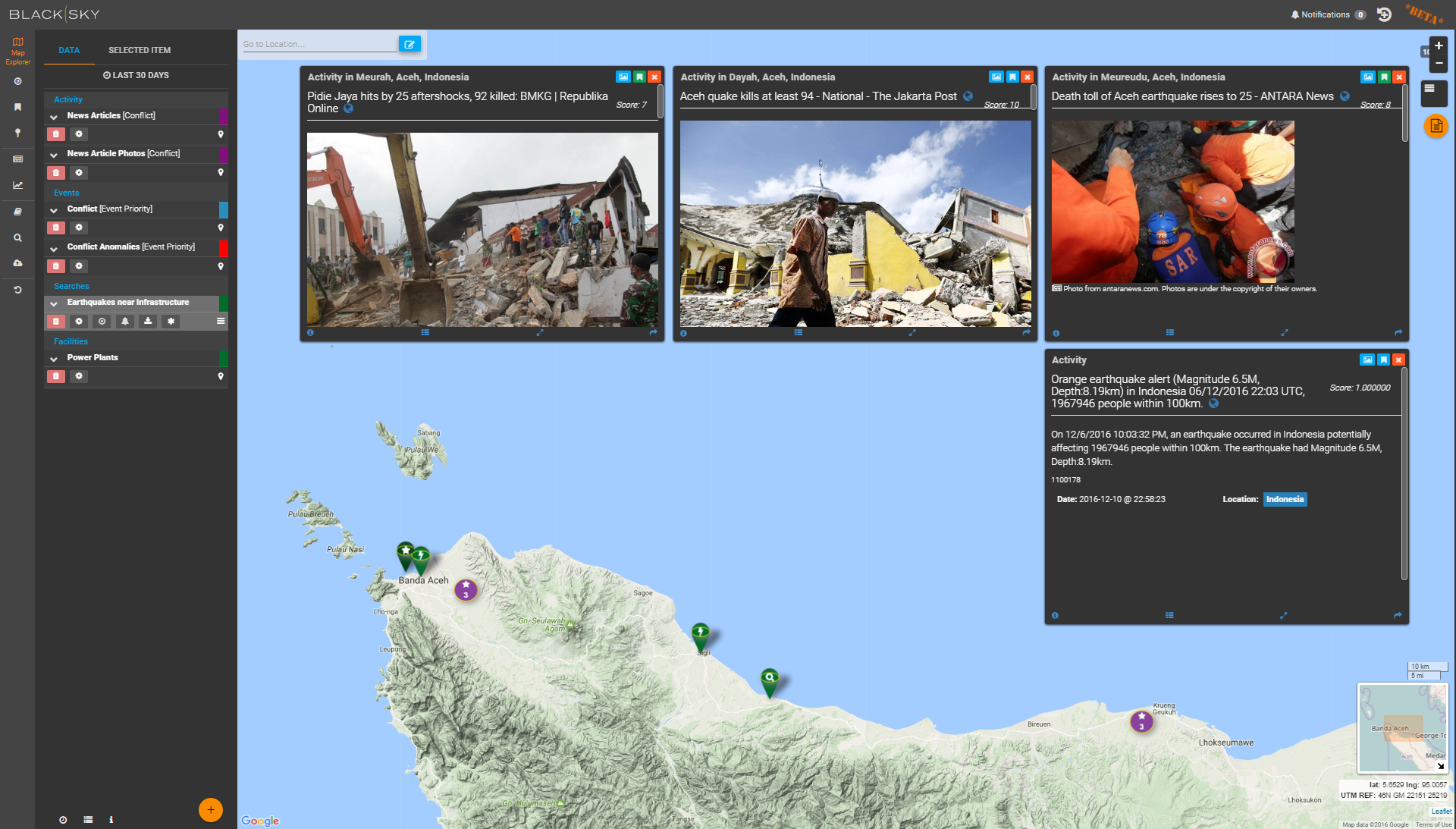
It’s been a bad week for natural disasters. As an additional example, here’s some details about an earthquake in Indonesia. For a humanitarian relief agency, having this information at your fingertips provides valuable insights you couldn’t get before. Now you can be confident where your next drop of relief supplies should go.
This is truly a revolutionary time in our industry. We hope you join us in this new era of global awareness. If you’d like to learn more about BlackSky, test drive the platform, or talk about joining our ecosystem, contact [email protected].
As a final note, we will be providing additional real world use cases on this blog. Stay tuned!